Trail Running Le Havre - Footing 2 Le Havre - Photo

Footing 2 Le Havre

© OpenStreetMap contributors
Length
Length
7.7 km
Max alt
Max alt
11 m
Uphill gradient
Uphill gradient
52 m
Km-Effort
Km-Effort  
8.4 km
Min alt
Min alt
1 m
Downhill gradient
Downhill gradient
53 m
Boucle
Boucle
Yes
Creation date :
2023-02-28 19:29:11.207
Updated on :
2023-02-28 19:45:20.016

(0 Reviews)

Running
Running
45m
Difficulty : Easy

Scan this QR Code to open this trail in the SityTrail application

FREE GPS app for hiking

Logo SityTrail SityTrail

IGN / Geographical institutes

Download SityTrail from the App Store Download SityTrail from Google Play

Logo SityTrail SityTrail Plus

The world is yours!

Download SityTrail from the App Store Download SityTrail from Google Play Download SityTrail on Huawei AppGallery

About

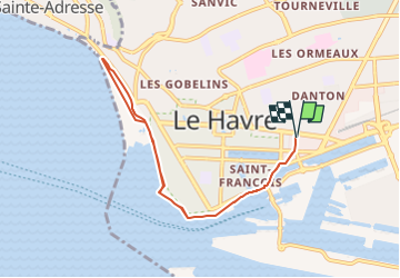
Trail Running of 7.7 km to be discovered at Normandy, Seine-Maritime, Le Havre. This trail is proposed by yannick-p.

Description

Petite sortie footing tranquille à partir du centre ville du Havre, direction le port puis la plage. Pas de difficulté de circulation, parcours sur une large esplanade avec vue sur le large et les côtes du Calvados.

Elevation profile

Positioning

Country:
France
Region :
Normandy
Department/Province :
Seine-Maritime
Municipality :
Le Havre
Location:
Unknown
Start:(UTM)
291374 ; 5486154 (31U) N.


Close
My subscriptions